


NASA Images Map Indonesia Fires
2016.09.21
Washington

 Satellite imagery provided by NASA shows fires and hotspots in Indonesia and neighboring countries.
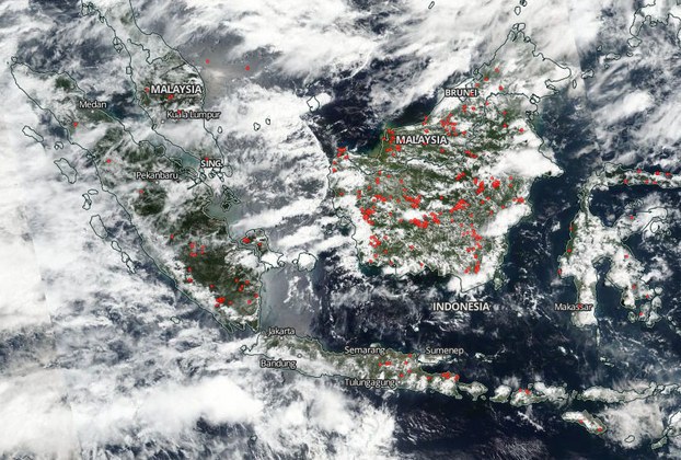 Courtesy NASA Worldview
Anyone can monitor illegal burning in Indonesia and elsewhere, thanks to a tool created by NASA that superimposes temperature data on near real-time satellite imagery.
To check for today’s hotspots, open the link to NASA Worldview. Red dots represent fires or volcanic activity. To obtain the latest imagery, move the grey slider at the bottom of the screen to the right. Use the +, - icons on the right side of the screen to zoom in or out.
Not all fires may be pictured, due to cloud cover or their relatively low intensity, scientists say. “Peat fires can smolder in the subsurface for weeks to months after ignition, often at temperatures too low to be detected accurately from space,” according to a recent study by researchers at Columbia and Harvard universities.
Last year, haze from agricultural fires in Indonesia blanketed a swath of Southeast Asia, creating a public health hazard, disrupting air travel and shuttering schools. The extreme conditions from the 2015 fire season in Indonesia may have led to tens of thousands of premature deaths in Indonesia, Malaysia and Singapore, the Columbia-Harvard study said.